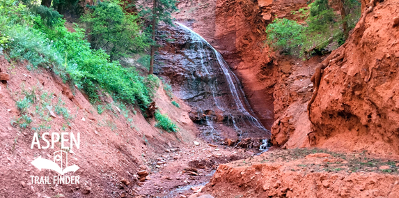
A waterfall flowing down Seven Castles Creek
Basalt, CO – Hard – Hike – Rocky
Seven Castles Trail is a very difficult trail you can hike and climb that follows Seven Castles Creek. This is an unmarked dangerous rocky trail and a fragile area in Basalt, CO. This is not an official trail. Access up Seven Castles Creek from Fryingpan Road crosses through private property. Please respect all private property.


 (50 votes, avg: 8.80 out of 10)


Know that this trail is difficult (requires climbing up waterfalls using slick ropes), dangerous (high water mark on the canyon walls is 15 feet up in places), and that it passes through private property. You also need to worry about rockfall from the cliffs above. If you’re thinking of doing this hike and see even a hint of rain in the forecast (or in the sky), just turn around.
Keep an eye on the weather and do NOT get caught in the narrow canyons if it rains up above! Many times I’ve seen mud come down that creek that resembled concrete, several feet deep, and floating large boulders! You can see the mud plastered on the canyon walls 10 feet high in some places. I know, I grew up next to that creek.
I tried this hike several years ago and never saw this gated access area. I started from fine pan road walking at seven Castle Creek. I climbed a series of different Ropes up waterfalls. It was an awesome hike, although I never actually reached the seven castles. I got to a point in the trail where a severed rope was hanging from a much taller waterfall than any of the previous ones I had climbed up. I attempted to go up the side here, but it was getting fairly steep and I was solo and storms were moving in, so… Read more »
A treasured beauty, this trail leads to an ancient Ute burial ground. Take time to think and act respectfully when you’re exploring this amazing place. The private property signs are new. If you follow the power line rd from tenor creek, just cut hard up the hill into the woods when you reach the property line with new no trespassing sings. You can access the trail without crossing any fences or marked property lines, and the old shmucks who bought out the property to put a fence around it are old, crotchety, and incapable, and will literally never run into… Read more »
Definitely a bit confusing to start, no signs or markers. Parked along the Fryingpan River just past the 4 mile marker. If you follow the creekbed 1/2 mile up there is a rope out and then you know you’ve found it.
Please take this down. There are numerous private residents there that are more than will to pull a gun on trespassers. Including walking the road that leads to it.
Ughhh Troy, it’s people like you that make this world a little less enjoyable at times. The trail lays on a creek bed that doesn’t impede on any private residents. It’s a beautiful hike that everyone should get to enjoy. It would be nice to see the community work with the county to come to a mutually beneficial resolution that benefits all parties. Instead, entitled jerks like you get butt hurt about people wanting to get outside and see a pretty piece of the planet we all share. No need to threaten people with guns, it’s not impressive.
Did the hike with my buddy today. Did not get shot and got to one of the most beautiful places in our valley. And didn’t go into anyone’s property. We were stopped by a CW ranger who asked for fishing license or game license and said that we were go to go with one of those. If you capable go for it !