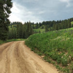
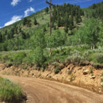
Connects: Arbaney Traverse, Larkspur Mountain Road (FSR #103), Hannon Creek Trail, Kobey Park, Forest Service Road #513, Kobey Trail Woody Creek, CO – Hard – Hike, Run, Mountain Bike, Horseback Ride, Dog Friendly – Dirt Kobey Park Road (FSR #508)…

Connects: Arbaney Traverse, Larkspur Mountain Road (FSR #103), Hannon Creek Trail, Kobey Park, Forest Service Road #513, Kobey Trail Woody Creek, CO – Hard – Hike, Run, Mountain Bike, Horseback Ride, Dog Friendly – Dirt Kobey Park Road (FSR #508)…
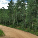
Connects: Arbaney Traverse, Woody Creek Road (CR #18), Woody Creek Trail, Johnson Creek Trail, Margy’s Hut, Kobey Park Road (FSR# 508) Woody Creek, CO – Hard – Hike, Run, Mountain Bike, Horseback Ride, Dog Friendly – Dirt Larkspur Mountain Road…
Connects: Gunnison County Road 3, Daniels Hill, Lead King Loop, North Lost Trail, Silver Creek Trail, Schofield Pass Road (FSR #317), Crystal City Road (FSR #314), Avalanche Pass Trail Marble, CO – Hard – Hike, Run, Mountain Bike, Horseback Ride,…
Connects: Aspen to Marble, Marble to Crested Butte, Daniels Hill, Lead King Basin Road (FSR #315), North Lost Trail, Avalanche Pass Trail, Arkansas Mountain Trail, Silver Creek Trail, Schofield Pass Road (FSR #317), Crystal City Road (FSR #314), Crystal City…
Connects: Castle Creek Road (CR 15), Midnight Mine Road (FSR #118), Aspen Mountain Sundeck, Richmond Hill Road (FSR #123)
Connects: Smuggler Mountain, Smuggler Mountain Road (FSR #131), Tootsie Roll Trail, 10th Mountain Trail, Behind The Sign (BTS) Trail, Hunter Creek Cutoff, Iowa Shaft Trail Aspen, CO – Medium – 1 Mile – Hike, Run, Mountain Bike, Dog Friendly –…
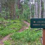
Connects: Thompson Creek Road (CR 108), Marion Cemetery Road (CR 123), Marion Cemetery, Sunlight to Powderhorn Trail (Winter) View Larger Map
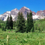
Connects: Maroon Creek Road (CR 13), Maroon Lake (9,585 ft), Maroon Bells Scenic Trail, Maroon Creek Trail (Maroon Bells), Four Pass Loop, Crater Lake Trail, Maroon-Snowmass Trail Aspen, CO – Recreation Area The Maroon Bells Scenic Area is an open…
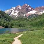
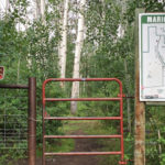
Connects: Maroon Creek Road (CR 13), Maroon Lake (9,585 ft), Maroon Creek Trail (Maroon Bells), Maroon Bells Scenic Area, West Maroon Portal Trail, Four Pass Loop, Crater Lake Trail, Maroon-Snowmass Trail Printable Maroon Bells Trail Map Aspen, CO – Easy…
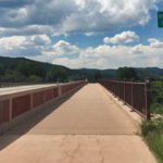
Connects: Highway 82, Maroon Creek Trail, ABC Trail, Chatfield Trail, Old Stage Trail Aspen, CO – Bridge The Maroon Creek Bridge, also called the Midland Bridge, is a historic steel trestle bridge along Highway 82 originally built for the Colorado…
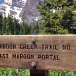
Connects: Aspen High School, Aspen Recreation Center, Maroon Creek Trail, Terral Wade Bridge (Tieback Nordic Bridge), Aspen Highlands, Silver Bar Campground, Silver Queen Campground, East Maroon Wilderness Portal, Maroon Creek Trail (Maroon Bells), East Maroon Trail, West Maroon Wilderness Portal,…
Connects: Maroon Creek Road (CR 13), East Maroon Wilderness Portal, East Maroon Trail, West Maroon Wilderness Portal, West Maroon Portal Trail, Maroon Lake (9,585 ft), Maroon Bells Scenic Trail Aspen, CO – Easy – 3.5 Miles – Hike, Run, Horseback…
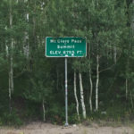
Connects: Highway 133 (West Elk Loop Scenic Byway), Huntsman Ridge Road (FSR #517), Ragged Mountain Road (FSR #898) Marble, CO – Mountain Pass McClure Pass (8,755 ft) is a mountain pass accessed by Highway 133 (West Elk Loop Scenic Byway)…
Connects: Castle Creek Road (CR 15), Little Annie Road (CR 15G), Hidden Treasure Trail, Aspen Mountain Sundeck, Richmond Hill Road (FSR #123), Nature Trail
Connects: Aspen to Crested Butte, Castle Creek Road (CR 15), Cooper Creek Road (Iron Mine Road), Mace Cabin, Pearl Pass Bridge, Pearl Pass Road (FSR #102), Montezuma Basin, Castle/Conundrum Peak Trail View Larger Map


